Maxar Awarded $35M in New Tasking Contracts by Two Government Customers in Asia-Pacific Region
Maxar Awarded $35M in New Tasking Contracts by Two Government Customers in Asia-Pacific Region
Contracts include direct access to very high-resolution imagery from Maxar’s WorldView Legion satellites and SAR imagery tasking via Maxar’s virtual constellation
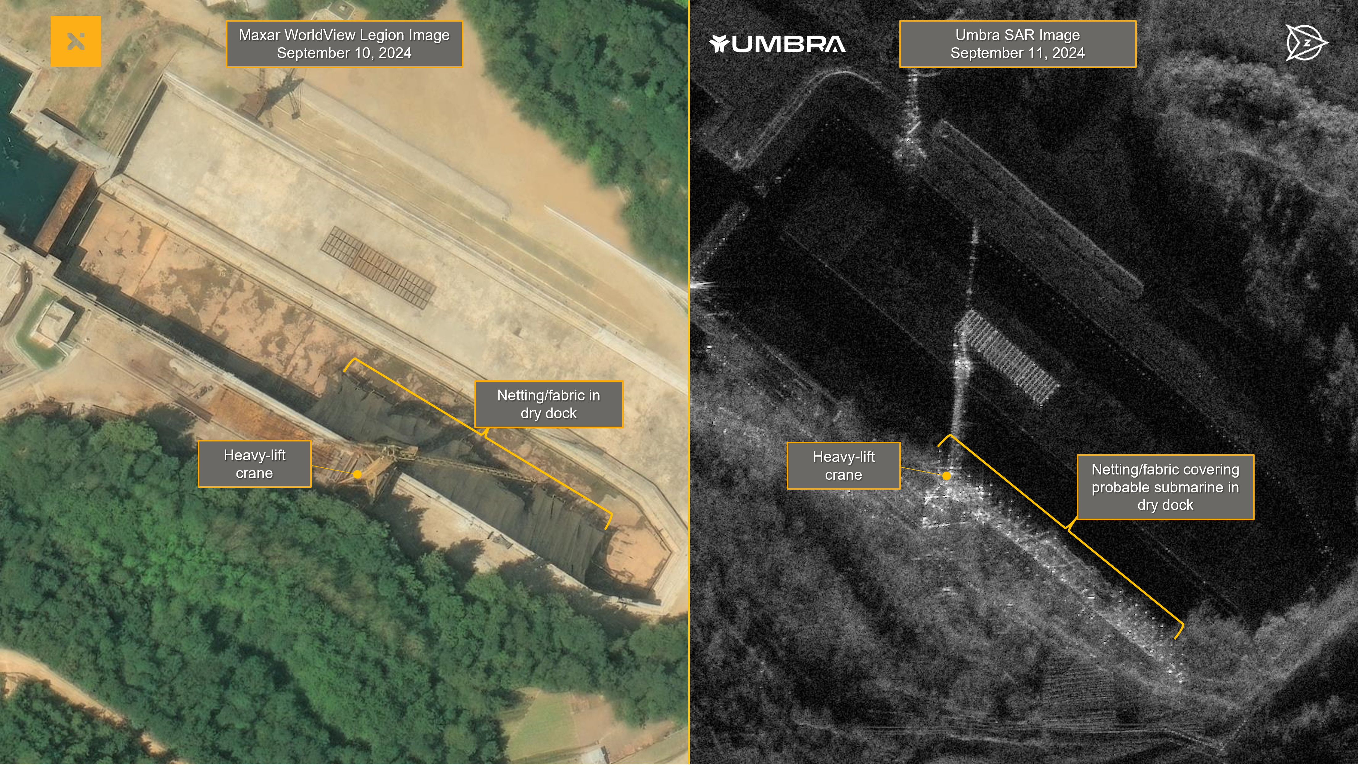
These two images showcase the power of Maxar’s virtual constellation. The Umbra synthetic aperture radar (SAR) image on the right shows a submarine underneath netting at a dry dock in Sinpo, North Korea. The netting is clearly visible in the very high-resolution WorldView Legion satellite image on the left. (Graphic: Maxar)
WESTMINSTER, Colo.--(BUSINESS WIRE)--Maxar Intelligence, a provider of secure, precise geospatial insights, today announced that it has been awarded a total of $35 million in new tasking contracts from two government customers in the Asia-Pacific (APAC) region.
Both contracts are built around a Direct Access Program (DAP) offering and include several “firsts,” including the first purchase of direct access to 30 cm class WorldView Legion imagery and the first use of Maxar’s virtual constellation capability in the APAC region to directly task ultra high-resolution synthetic aperture radar (SAR) imagery from Maxar partner Umbra.
“With rising geopolitical insecurity around the world, our customers need more advanced geospatial insights that can provide them with near real-time situational awareness over key areas of interest,” said Anders Linder, General Manager, International Government at Maxar. “With four WorldView Legion satellites on orbit, including two in mid-inclination orbit, we offer the most 30 cm class tasking capacity from dawn to dusk. Combine that with the option to directly task SAR imagery through us, our customers can collect ground truth insights 24/7, giving them the transparency they need, when they need it.”
Maxar’s DAP offering enables defense, intelligence and commercial customers to integrate ground stations with Maxar’s satellites, giving them dedicated capacity with guaranteed delivery speeds. Customers can task Maxar satellites up to 15 minutes prior to an imaging event and receive data in real time.
Through Maxar’s dedicated access agreement with Umbra, customers are also able to directly task Umbra’s SAR satellites through Maxar’s platforms—part of Maxar’s virtual constellation capability. Umbra’s SAR imagery, which can be collected at 25 cm resolution, enables customers to monitor activity at night and in all weather conditions, serving as a powerful complement to Maxar’s very high-resolution electro-optical imagery.
About Maxar Intelligence
Maxar Intelligence is a leading provider of secure, precise geospatial insights. Operating the most advanced commercial Earth observation constellation on orbit, we use the power of very high-resolution satellite imagery and software technology to deliver mission success on Earth and in space. Our secure, AI-powered products and services deliver ground truth in near real-time to keep nations safe, improve navigation, protect our planet, speed up disaster response and more. For more information, visit www.maxar.com.
Contacts
Tomi Maxted
Maxar Intelligence media relations
tomi.maxted@maxar.com