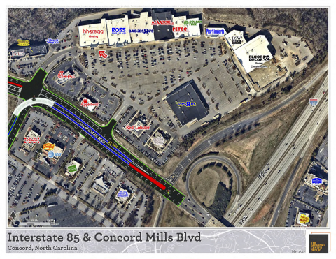
SOUTH JORDAN, Utah--(BUSINESS WIRE)--Nearmap’s crystal-clear, high-resolution aerial imagery is now enhancing the real estate maps The Shopping Center Group’s (TSCG) team of retail real estate brokers use for location and market analysis.
Providing quality aerial imagery is a critical element in creating the most accurate, detailed maps available for TSCG brokers and clients. Through Nearmap’s integration with ArcMap from Esri, TSCG incorporates Nearmap imagery as an enhanced storytelling vehicle, providing information such as:
- History - Because Nearmap’s images are captured at least two times per year, brokers are able to show clients the history of growth in a particular area. Imagery also reflects leaf-off and leaf-on comparisons, allowing for unobstructed views of ground-level assets like sidewalks, utility boxes and parking.
- Higher resolution - With 2.8-inch GSD, quality images lead to better measurements, allowing TSCG brokers to effectively plan and visualize maps for clients.
- Points of interest - With crystal-clear images, The Shopping Center Group brokers can easily identify street details, neighboring structures, signage and traffic patterns.
- Increased efficiency - Vivid imagery has reduced the need for repeat, extensive on-site property visits, allowing both broker and client to spend valuable time securing other details.
“Nearmap has now filled gaps we found in our previous maps,” said Gregg Katz, director of innovation and technology at TSCG. “The service has given us the ability to show newer, clearer images, especially as we zoom in and drill down on particular sites.”
Partnering with Nearmap has been a win-win relationship for TSCG, allowing the firm’s GIS mappers to create the highest quality maps for brokers.
“Nearmap lets our brokers get up close and personal and see the sites in a much different light,” said Bryan Chandler, GIS manager for TSCG. “Now we have the option to pull in Nearmap to give the brokers exactly what they are looking for. Having Nearmap in our tool belt has allowed us to really meet the broker’s needs.”
Founded in 1984, The Shopping Center Group is recognized as the preferred, retail-only real estate service provider known for dependable service, proven integrity, indisputable commitment and unparalleled market knowledge. With 21 offices coast-to-coast, the firm maximizes outcomes in tenant representation, project leasing, property management, capital markets services, and property dispositions for landlords, developers, investors, financial institutions, retailers and restaurants throughout the United States. In 2016, The Shopping Center Group facilitated over 2,000 transactions totaling over $2 billion. Its third-party portfolio includes exclusive leasing assignments for over 800 retail centers, totaling over 60 million square feet and management agreements for over 10 million square feet of retail property. The firm exclusively represents over 400 retailers, restaurants and entertainment venues.
Named one of Esri's 2016 Special Achievement in GIS award winners, The Shopping Center Group’s investment in GIS mapping technologies has been instrumental to its success.
“We employ a team of 28 GIS mappers who work with over 100 brokers to create maps that reflect all the information needed to effectively assess a location," Chandler said. “Quality imagery is an absolute necessity.”
Nearmap, a location content provider specializing in frequently updated aerial imagery, captures images that are 2.8-inch GSD. Superior to the satellite imagery TSCG was previously relying on, Nearmap allows the retail real estate firm to create detailed maps, reflecting everything from a high level in the air down to a zoomed-in perspective.
Nearmap will be showcasing its latest imagery solutions at the Esri User Conference in San Diego, July 10-14. Stop by booth 2227 to see it in action.
About Nearmap
Nearmap brings the real world to you. We capture, manage and deliver the most current location content in the world, allowing businesses and governments to explore their environment easily. With Nearmap, organizations unlock opportunities that consistently inform decision-making and transform the way they work. Our high-resolution, frequently updated aerial imagery is 2.8-inch GSD, better than satellite imagery. Delivered within days of capture, Nearmap shows changes over time. Users save time and money, reduce site visits and efficiently plan with current, clear imagery.
Nearmap is delivered through a refreshingly easy-to-use interface called MapBrowser™ or accessed via Esri® and Autodesk products.
Free trials of Nearmap are available. For more information, visit http://go.nearmap.com.


